The Age of Convergence — When Four Oceans Spoke at Once
Fengshen in the Philippines, Shakti in the Arabian Sea, Melissa in the Caribbean, Chenge by Madagascar — the month storms converged, and what readiness really means
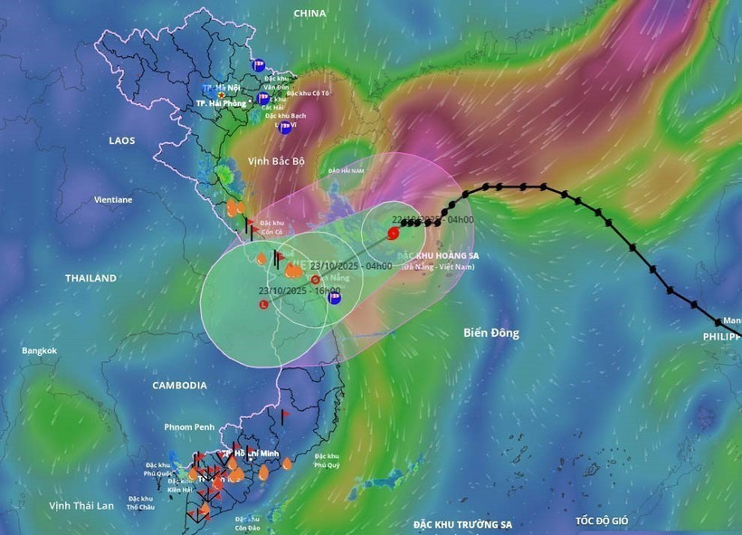
Luzon under water: a storm that was not the strongest, but emblematic of a new normal — slower, wetter, wider.
In the pre-dawn hush of Luzon, the wind came first — a rattle, not a roar. By sunrise, the sea was in the streets. Tropical Storm Fengshen, never the strongest on record, was something subtler and more dangerous: a slow, water-heavy system that stalled over river basins. As PAGASA warnings scrolled across phones, evacuation drills gave way to the old choreography of buckets, ropes and makeshift rafts.
What made October 2025 extraordinary was not a single storm but the chorus: while Fengshen flooded the Philippines, Shakti spun up over the Arabian Sea, Melissa threatened the Caribbean, and Chenge traced a lazy spiral east of Madagascar. Four theatres. One overheated ocean engine.
A Storm Named Fengshen
Metro Manila’s upgraded flood-control dams held until controlled releases began; evacuation centers filled quickly but functioned. By October 17, a national calamity was declared and emergency credit lines opened. The lesson was familiar: warnings have improved, but exposure — housing on floodplains, paved wetlands, informal embankments — still converts weather into catastrophe.
Four Oceans in Turmoil
Cyclone Shakti (Arabian Sea): Alerts from India’s IMD triggered coastal evacuations in Gujarat and fishing bans issued via INSAT-3D channels. Tropical Storm Melissa (Caribbean): Flood watches across Haiti and Jamaica as Copernicus maps showed coastal belts inundated. Tropical Storm Chenge (SW Indian Ocean): No landfall, yet formed over waters nearly a degree above the 30-year average — a symptom of a basin expanding its cyclone nursery.
| Storm | Basin | Peak wind (km/h) | Rainfall (mm) | Displaced (people) | Fatalities | Profile |
|---|---|---|---|---|---|---|
| Fengshen | W. Pacific | 120 | 450 | 90,000 | 34 | |
| Shakti | Arabian Sea | 105 | 120 | 12,000 | 0 | |
| Melissa | Caribbean | 85 | 400 | 15,000 | 9 | |
| Chenge | SW Indian Ocean | 70 | — | — | 0 |
Why So Many Storms?
NOAA confirms record sea-surface temperatures across the western Pacific and Indian Ocean; a fading El Niño plus a positive Indian Ocean Dipole overlapped, enhancing convection. Warmer oceans hold more latent heat — roughly 7% more moisture per °C — turning storms slower and wetter. Ocean heat content down to 700 m stayed unusually high, reducing post-storm cooling and enabling back-to-back formations.
The Economics of Readiness
Every dollar in prevention saves six to seven in relief. Yet less than a fifth of climate finance to low-income states lands in adaptation infrastructure. The Philippines credits a decade of flood-control upgrades for lower fatalities; India’s cyclone shelters and SMS alerts have moved millions ahead of landfall. Haiti and Madagascar still face adaptation budgets below 1% of GDP and rely on post-disaster aid, not pre-disaster finance.
Institutional Readiness
Readiness is more than sensors. It’s zoning, mangroves, drainage, drills — governance made physical. ASEAN, CARICOM and the Indian Ocean Commission now share data; catastrophe bonds and parametric insurance are growing but not yet scaled. Money builds walls; institutions decide whether they stand.
Epilogue — The Season That Didn’t End
As Luzon drains, the satellite loops keep spinning. October 2025 was not a month but a meteorological sentence — four storms reading the same verdict aloud. Adaptation is no longer a promise; it’s the price of staying. The future will reward jurisdictions that treat weather like infrastructure and readiness like a right.
Policy takeaway: Make adaptation automatic. Hard-wire early-warning budgets, parametric payouts, and minimum housing standards into law. Disasters should trigger finance, not debates.
Notes on sources. WMO seasonal outlooks; NOAA Global Climate Report (Oct 2025); PAGASA, IMD, EUMETSAT, Copernicus EMS storm bulletins; World Bank disaster-risk financing guidance. Figures rounded to latest public releases.
Add comment
Comments